Geography
The Columbia River Gorge sits at 45.706630999999990000 latitude and -121.639490900000000000 longitude. Covering nearly 300,000 acres in southern Washington and northern Oregon it offers tons of activites from sailing to wine tours. The Columbia river gorge was formed in the Miocene era (12-17 million years ago) and the Pleistocene era (700,000-2 million
years ago). The bigggest change of its shape happened at the end of the last iceage when the Missoula Floods chilsed the steep walls of the Columbia Gorge and flooded the river. The end result left many layers of volcanic rock exposed, which is what we can see today. The Gorge was formed thousands of years ago by many powerful natural forces; wind, water, sand and ice.
years ago). The bigggest change of its shape happened at the end of the last iceage when the Missoula Floods chilsed the steep walls of the Columbia Gorge and flooded the river. The end result left many layers of volcanic rock exposed, which is what we can see today. The Gorge was formed thousands of years ago by many powerful natural forces; wind, water, sand and ice.
Climate
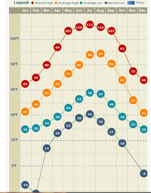
In past years the gorge has experienced record high and low temperatures for the area of 112°F in July of 1956 and the low temperature of -21°F in February of 1950. The western part of the Gorge is lush and green with waterfalls as the eastern side is dry and hot.